God for us to design products, we are the porters of nature!


My son and fearless faithful rock collecting partner, who by the way will turn 18 years of age this month, and I located the three above mentioned former molybdenum sites. We did so over three separate collecting trips during the summers of 2008-2010. I will roll all three trips into one article dealing with molybdenum.
We should first start out with an explanation of the mineral.
Mr. F. J. Johnston states in his report…there are more than 300 reported molybdenum occurrences
in Ontario but there are no mines presently producing the metal ( as of his report dated 1968).
Practically all of Ontario's production was during World War I. Most of the ore came from hand-cobbing operations from Eastern Ontario. However small shipments of ore have been made since that time and particularly prior to and during World War II. The last molybdenum shipments were in 1964 from Pax International Mines Limited.
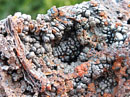
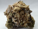
Molybdenum occurs in nature only in chemical combination with other elements. A number of molybdenum-bearing minerals have been identified, but the only one of commercial significance is molybdenite. Molybdenite (MoS2) is the most common mineral of molybdenum. It physically resembles graphite due to its softness and greasy feel but is distinguished from it in a number of ways. Molybdenite is soluble in nitric acid. Molybdenite leaves a bluish-gray mark on paper and a greenish-gray streak on porcelain while graphite gives a gray-black streak porcelain. Under the oxidizing flame of the blowpipe molybdenite gives off sulphur fumes, on charcoal colorful coatings surround the sample. A violet color is commonly seen between the divided cleavage flakes of molybdenite.
The physical characteristic that make molybdenum unique is that it has a very high melting point, 4,730 degrees Fahrenheit. This is 2,000 degrees higher than the melting point of steel. It is 1,000 degrees higher than the melting temperature of most rocks. It has the sixth highest melting point of all of the elements.
Molybdenite, molybdenum sulfide, is the major ore mineral of molybdenum. It was rarely found as crystals, but is commonly found as foliated masses in Ontario. This means the mineral forms folia or layers, like the mineral mica. It is metallic gray, has a greasy feel, and is very soft at only 1 on Mohs' hardness scale. Its softness, metallic luster and gray color led scientists to mistakenly believe it was a lead mineral. Geologically, molybdenite forms in high-temperature environments such as in igneous rocks. Some molybdenite forms when igneous bodies contact rock and metamorphose, or change, the rock. This is called contact metamorphism

Molybdenum was first discovered in 1778 by a Swedish chemist named Carl William Scheele who thought he was studying a sample of lead. Scheele noticed a visual similarity between his sample and that of lead, but based upon his studies, he conclude that the ore sample did not contain lead, instead it was a whole new element. He named this element molybdenum after the mineral molybdenite. Named from the Greek word "molybdos, which actually means lead.
The mineral scheelite,calcium tungstate-molybdate) was named after Scheele in honor of his discovery of molybdenum.
The metal was first isolated in 1781 by Peter Jacob Hjelm. But, a commercial use for molybdenum was not identified until the early 1900's. Molybdenum makes for stronger steels with greater resistance to corrosion and damage. Industrial and military applications during the First World War saw the demand for molybdenum rise dramatically as alloyed steels used for transportation and armor plating increased with the war effort. It was found that molybdenum could impart an impact resistance similar to tungsten when alloyed with steel, with far less weight.
As a special side note, reported in the Annual Report Volume dated 1918 of the Ontario Dept. of Mines it states… It is used as an ingredient of special tool steel, and before the war was supplied to the British steel-makers in the form of ferro-molybdenum by Germany. When Germany cut this source off due to the war, the British authorities sent an urgent appeal to Canada, among other British countries, for molybdenite concentrates, and fixed a price per pound. Ontario responded by increasing her output of this mineral, which in 1916 amounted to 24,562 pounds, to 77,517 pounds in 1917, and 47,614 pounds in 1918. Most of this was exported which was undertaken at Orillia. Part of the exports went to France. It is said that the lining of the famous 75-millimetre guns so effectively used by the French in the war was of molybdenite steel.
Molybdenum was primarily used as an alloying element in iron and steel.
1. Steels containing less than l percent and are used extensively in the automotive industry and in the manufacture of farm implements and railway forgings and bolts.
2. Steels containing more than l percent and are much used for permanent magnets, rustless steels, dyes, and high speed tools.
I personally worked in the steel industry for 34 years. There are as many different types of steel as there are types of rocks and minerals. Each type of steel, like rocks or minerals, has it’s own chemical composition and properties which differentiate it from other types, not only from within the same class but from within an entire group. Additives such as molybdenum are used in the steel making process to produce “specialty steels”. These types of steels are produced for their special unique qualities: strength, heat resistance, rust inhabitation, electrical properties. Other mineral additives can include: nickel, chromium, manganese, silicon just to name a few. More exotic steel types can include titanium.

Today the two largest uses of molybdenum are as an alloy in stainless steels and in alloy steels. These two alone consume about 60% of the molybdenum needs in the United States.
1. Stainless steels include the strength and corrosion-resistant requirements for water distribution systems, food handling equipment, chemical processing equipment, home, hospital, and laboratory requirements.
2. Alloy steels include the stronger and tougher steels needed to make automotive parts, construction equipment, gas transmission pipes.
3. Other major uses as an alloy include tool steels, for things like bearings, dies, machining components, cast irons, for steel mill rolls, auto parts, crusher parts, super alloys for use in furnace parts, gas turbine parts, chemical processing equipment.
4. Molybdenum also is an important material for the chemicals and lubricant industries. It has uses as catalysts, paint pigments, corrosion inhibitors, smoke and flame retardants, dry lubricant (molybdenum disulfide) on space vehicles and resistant to high loads and temperatures. As a pure metal, molybdenum is used because of its high melting temperatures (4,730 F) as filament supports in light bulbs, metal-working dies and furnace parts.
The Ontario Dept. of Mines, statistical files for all of Ontario dated 1964, shows molybdenum production, measured by concentrate per pound.
Production Year / Concentrate per Pound
1902…
1903…
1915…1,068
1916…24,562
1917…77,517
1918…47,517
1931…1,222
1937…16,500
1938…13,000
1939…482
1942…423
1944…2,815
1964…11,393
The peak production years being 1917 and 1918, in fact more concentrate was produced in 1917 alone than all of the other production years combined, excluding 1918.
During the time period 1915-1918, a number of molybdenum concerns, in Haliburton County, were actively working prospects for this mineral. The following lists only a few of those concerns.
Cardiff Township
Orr-Kidd Prospect
Powell and Anderson Prospect
W. E. Joiner for Paudash Lake Molybdenite Mines, Limited
Evans, O'Brien, or Treasure Hill Mine
Brough Lake Molybdenite, Limited
Mathews-McMahon Prospect
Dixon Mine
R. Dickson and A. Riddell Prospect
Joiner Property
Glamorgan Township
British Molybdenite, Limited
Harcourt Township
Land and Immigration Company, Limited, of Haliburton, under the direction of S. Dillon Mills
Lutterworth Township
A. Y. Hopkins
Hamilton Molybdenum Alloys Company, Limited
Monmouth Township
Anderson Prospect
Lillico Mine
G. Padwell
Madill Property
Padwell Property
Johnston Occurrence
Wilberforce Molybdenite Company, Limited
B. E. MacDougall Prospect
Dominion Molybdenites, Limited, Incorporated
Site: American Molybdenite :
Location: Monmouth Township, Haliburton County
Minerals: molybdenite, pyrite, pyrrhotite.
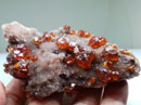
Located about 500 feet from the former Canadian National Railway line and four-tenths of a mile west of Wilberforce station. An outcrop of molybdenite about 140 feet wide and 280 feet long was surface stripped. At the north end were 2 shafts measuring 30 and 40 feet deep. The outcrop consists of an aggregate of pale-green pyroxene and white albite with a very sparse amount of flakes of molybdenite. Within the pyroxene-albite rock are numerous remnants or inclusions of rusty biotite paragneiss containing disseminated pyrrhotite.


The property was owned by Dominion Molybdenites, Limited, incorporated in May, 1917, the name of which was changed to American Molybdenites, Limited, in August, 1917.
In 1917, American Molybdenite Ltd., shipped 58.6 tons of material grading 0.20 percent ore to the Mines Branch, Ottawa and 27.2 tons of 0.39 percent ore to Renfrew from a quarry on the property. A total of 320 pounds of molybdenite was recovered.
The Molybdenum Products Company optioned the property in 1918, and it has since reverted to American Molybdenites, Limited
In 1918, Molybdenum Products of America optioned the property and installed a 125-ton concentrator.
In 1919, the property reverted back to American Molybdenite Ltd.
In 1965, New Far North Exploration Ltd. acquired the property as part of 26 contiguous claims in the area. A. geochemical survey and 2 diamond drill holes totaling 568 feet were completed. Molybdenite occurs in a mineralized pyroxenite contact zone between granite and crystalline limestone.
Conclusion: Low-grade ore, the deposit is too low grade to be of any economic importance
The Molybdenum Products Company, Limited, operated on two properties in Monmouth Township, one at lot 32, concession XV, the other at lot 32, concession XVI.
The power plant consists of two R.T. boilers, one Jenckes 150-h.p., and one Goldie and McCulloch 180-h.p.; one 135-h.p. compound Wheeloek-Goldie and McCulloch engine, and one 50-h.p. Erie Engine.
The ore is hoisted in a 1 and 1/4-ton skip from a quarry up a 10-degree tramway to the mill. The skip dumps into a bin holding 200 tons, which is the estimated capacity of the mill per 24 hours. The ore is crushed to one inch by an 11 by 26-inch jaw crusher. It is then hoisted by a bucket and chain elevator to a 175-ton bin, whence it is fed by an automatic feeder to a No. 64 Marcy ball mill. The discharge from the mill is elevated to a 14 ft. 8 in. Dorr duplex classifier. The oversize from the classifier returns to the ball mill, and the undersize goes to five Callow roughing cells. The concentrates from the latter pass to two Callow cleaner cells and the tailings to waste. The concentrates from the cleaning cells pass to an 80-mesh Callow screen. The oversize from the latter is the final product, and is de-watered in a drag de-waterer; these concentrates are then dried over a brick oven. The tailings from the cleaning cells return to the roughing cells, as does also the undersize from the Callow screen. The mill and tramway were completed in December, 1918, and work was then begun in the quarry.
The officers of the company were: president, O. D. Walters, Council Bluffs, Iowa; vice-president and managing director, M. B. E. Gordon, Wilberforce, Ontario.; secretary-treasurer, George Urquhart, St. Paul, Minn.; directors, the above mentioned with, J. J. Hennen, St. Paul, Minn., and George Moss, Lohrville, La.
Forty men were employed. I. L. Church was foreman at the mine, and J. C. Duval at the mill. Annual Report Volume dated 1918 of the Ontario Dept. of Mines.
My report for the American Molybdenite Mine ……. Before any attempt is made to explore any site on private property, obtaining property owner permission is always necessary.
The area surrounding the former site appears to be a newer residential development. My guess would be that this area was once a much larger property. It was most likely subdivided into smaller residential sized parcels.
From the information I had gathered, the site is in the small town of Wilberforce. Getting to the site was another matter. Obtaining permission to enter the property was very difficult. We believed the site to be in a wooded area directly behind the house in the photo. During our collecting trip in 2008, we made several attempts to obtain permission to enter the property, each unsuccessful. Driving to the location several different times over a period of one week, we found no one home each time. Without permission to enter, we did not visit this site during this trip.

We did not attempt to visit the site in 2009, but during our trip in 2010 the site was placed back on the agenda list. With luck running with us, we were given the green light to proceed into the wooded area. I did not expect to find much in the way of collectable material at this former site since molybdenite only ran .2-.3% and those figures were for hand cobbled material. I did want to locate, explore and photograph the site for historical reasons however. Within 100 feet of entering the woods we came across a fairly steep hill. We guessed the mining site would be located at the base of the hill. Overgrown with pine trees, the densely packed trees and brush made visibility and photo taking difficult. Because the trees are so densely grouped, practically all of their lower branches bear no needles due to the lack of sunlight. It was time consuming weaving in and out of the trees making our descent down the hill.


Large rocks and boulders are seen strewn in numerous places, we investigated several piles and found small traces of molybdenite.


Being on the right track we continued farther, locating the main trench, rock walls signaling the extent of the trench size. I was very happy to have found this old site. I stopped for a few minutes just to enjoy the moment. Climbing down maybe 4-5 feet into the main trench very large jagged boulders lay piled with smaller sized rock on top. From what I could see the entire bottom of this trench was bedrock. We would search through the piles of waste material hoping to turn up a few flakes of molybdenite. A large number of the rocks we examined contained pale-green pyroxene and white albite. A few small flakes of molybdenite were also seen in several of these rock piles.

Making a small pile of our own, we gathered our samples of molybdenite bearing rock in one spot. I later sorted the possible samples only collecting a few specimens to take with us. Naturally, I selected the larger sized flakes of molybdenite.


This site doe have historically value and if one looks at it in this light, it is an excellent site to visit. From a collecting point of view it does not offer much in the way of collectable molybdenite specimens, though specimens are available. I was happy to have been able to locate and to explore this former site and particularly happy we did collect a few specimens. I was however a little disappointed in that due to the heavy overgrown condition it was not a good spot for over all photo taking.
Site: Padwell Mine:
Location: Monmouth Township, Concession XV, Lot 11, Haliburton County
Minerals: molybdenite, pyrite, pyrrhotite.

In 1916, G. Padwell sank a pit 70 by 30 feet and 15 feet deep from which 55 tons of hand-picked ore, grading 1.4 per cent, from which 1,268 pounds of molybdenite was recovered and shipped to the Mines Branch, concentrator in Ottawa.
In 1917 he shipped 62 tons of 1.0 percent MoS2 to the International Molybdenum Co. concentrator at Renfrew.
Additional development on this property and the lot to the south was performed by Canadian Molybdenite Mines, Limited, in 1940.
In 1966, Georgia Lake Mines Ltd., acquired the property as part of 30 contiguous claims in the area. The company had magnetic, induced polarization and geochemical surveys as well as 4 diamond drill holes totaling 428 feet done on the property.
Molybdenite occurs in a flat-lying mineralized pyroxenes zone at the contact between limestone and senate gneiss.
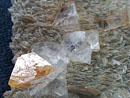
On the site of the old Pad well workings there is now a pit 150 feet long, 10 to 50 feet wide, and from l to 10 feet deep. This pit exposes cream, pink, green, and white banded crystalline calcite containing phlogopite or diopside and inclusions of hornblende gneiss. At mid-center of the pit there is a mass of rusty basic pegmatite, which contains pyrite and a few flakes of molybdenite.
It appears that G. Padwell in 1916 and 1917 mined out a small body of ore and that later exploration has failed to reveal any commercial bodies of molybdenite.
Conclusion: Low grade ore, the deposit is too low grade to be of any economic importance
In 1916, Mr. G. Padwell was not the kind of man who would sit on the porch and watch paint rust, no, on the contrary… not only working the above site concession XV, lot 11, he also opened up a quarry face 50 feet long and about 10 feet high on lot 13, concession XIII, Monmouth Township. From this site he made a shipment of 1,300 pounds of hand-picked ore, running 3.85 per cent MoS2, to the Mines Branch concentrator in Ottawa.
In 1939, the Canadian Molybdenite Mines, Limited, enlarged the quarry to a length of 130 feet from east to west and a width of 120 feet from north to south. One pit in the northwestern part of the quarry floor measured 25 by 30 feet and 15 feet in depth; another in the southeastern part measured 40 by 25 feet and from l to 4 feet in depth
The country rock is flat-lying hornblende-feldspar gneiss. The hornblende gneiss is slightly mineralized with large flakes of molybdenite, coarse pyrite, and pyrrhotite. This mineralization is very spotty, some bands of gneiss several feet thick showing none. Cutting the gneiss are several 1-4 foot wide pink pegmatite dikes. The deposit is considered to be of no economic importance
My report for the Padwell Molybdenite Mine …….This site like the American Molybdenite site produced a very low percentage of ore. Due to the fact different mining operations were working here in ’16, ‘17’ ‘40’ and ’66 it is difficult if not impossible to know where Mr. Padwell left off and the other mining operations began. Without detailed information and mining maps it was unknown to us which mining operation worked where and did what.
We followed Sabina’s directions to the basic area, parking the vehicle off the dirt roadway. The site may have been easy for Sabina to locate thirty years ago but now her directions are quite wanting in detail. All we knew from her directions was the site was on the right side of the road.

The area is densely forested, not showing any signs of once being a mining site. At the time of our visit (2009) the area was not posted and there were no signs to suggest trespassing is prohibited. We packed our gear and headed into the woods. I always use a compass and a GPS unit when leaving a parking site and entering an unknown area. This is a great tip for those of you who don’t use directional equipment. In any area, whether it be of thick dense tree and brush or open grassy fields, it is very easy to become disoriented when unfamiliar with the surroundings. Using both a compass and a GPS unit will ensure your safe return. I use both simply because in dense tree growth, extreme cloud cover or a rain storm the satellite signal to a GPS unit can be lost. Having an old fashion compass can be an extremely valuable asset, plus it does not require batteries. Since I mentioned batteries… entering a remote area with a GPS unit and not carrying extra batteries is not wise. Always carry new unused batteries with you. I always consider the safety factors before entering any unfamiliar area.


We walked into the woods on a course perpendicular to our vehicle for approx. 300-400 yards looking for any signs of ground disturbances. Straight ahead of us were what appeared to be mounds of soil forming straight lines on the forest floor, obviously not natural formations. As we approached the mounds we could see they appeared to be piles of waste material thrown from the trenches running parallel to them. I was very excited at our discovery. This was the Padwell site. The mounds themselves are maybe 4-5 feet tall.

Knowing we were in the correct area we explored the surrounding area doing a 360-degree recon before examining any of the rock material. Taking photos and GPS readings are always the first thing to do. We located a slight hillside, which may or may not be the hill mentioned by Sabina. There are three trenches of varying widths from 10-12 feet wide and 4-6 feet deep and varying lengths all in different stages of erosion. The entire area is overgrown. All the mounds are covered with several inches of soil and decomposing vegetation from years and years of being undisturbed. In spots, a trench may be clear and open while in other spots it may have caved in on itself. Fallen trees cover several spots making these spots inaccessible. The area seems to be a low lying area as there is evidence of flooding being a common occurrence possibly from a nearby creek.

After an hour or so of exploring, we selected one mound to dig into. Unearthing sections of the mound we were surprised to discover the mound was actually a large pile of rock, rocks by the thousands lay just under the upper layer of soil and leaves. All this rock had to have been removed from the trench due to its proximity. The rock appeared to have been possibly hand stacked. If it were, Mr. Padwell may have done this in 1916-17. As we removed the dirt and debris covering the rock it was clear the rock was from different layers.

As we removed each rock from the pile, we separated them into smaller piles by color. Three piles were formed, a creamy colored, a pink colored and white crystalline calcite pile, some with inclusions of diopside. Our largest pile was that of the white crystalline calcite. It was amazing all this waste rock was hidden like it was. Several specimens of molybdenite were located along with very small bits of pyrite and diopside as inclusions in the waste rock.We spent a number of hours digging and removing piled rock.

I am amazed every time I visit a site like this and try to imagine what was going on when the site was active. Did Mr. Padwell actually dig here almost one hundred years ago? I wondered if the rocks on the piles were thrown here by hand from the trenches? Was the molybdenite hand separated here before being shipped to the concentrator? We found no evidence of a railed cartway. I did not locate information concerning how the ore was moved from the site. Maybe it was by horse and cart?
Mosquitoes are always a concern, they were especially brutal in the lower wetter ends of the trenches forcing us to constantly use bug spray and wear head netting. Let this be another tip … always be prepared. There are a few very important things one must pack with their personal gear. Every site will pose different demands on the collector and you must meet the situation. Low lying, wet areas will contain hungry mosquitoes. Researching a site thoroughly will allow you to determine what particular gear may be needed for that site. Walking into an unfamiliar area, unprepared is foolhardy and can be extremely dangerous. You should also have some knowledge of basic first aid, especially for cuts of all types and broken bones. Don’t fool yourself into thinking something can’t or won’t happen to you. Always practice safety first and be prepared for the unexpected.


Site: Wilberforce Molybdenite :
Location: Monmouth Township, Haliburton County
Minerals: molybdenite, pyrite, pyrrhotite, fluorite, titanite.
The Wilberforce Molybdenite Company, Limited opened up a molybdenite prospect on lot 33, concession XV, Monmouth Township, in 1917. The workings are on a bare knoll just west and south of some farm buildings. Just north of a side road there is a trench which is 100 feet long, 10 feet wide, and 10 feet deep and has a pit at the west end which was 20 feet deep. Stripping and small pits expose rusty weathering mica-pyroxene gneisses. The trench banded gneiss containing bands of phlogopite and pale-green pyroxene; one band consisting of calcite, actinolite, and minor quantities of fluorite and titanite. The gneisses are cut by a dikelet of feldspar-apatite-pyroxene rock. Rusty gneisses contain pyrrhotite, and flakes of molybdenite.
.
In 1918, Wilberforce Molybdenite Co. Ltd. Did considerable surface work in the area.
In 1965, New Far North Exploration Ltd. acquired the property as part of 26 contiguous claims in the area on which the company did a geochemical survey for molybdenum. Molybdenite occurs in a mineralized pyroxenite contact zone between granite and crystalline limestone.
Conclusion: Low grade ore, No further development was justified in view of the negligible amount of molybdenite present. It was reported locally that some additional pitting in the trench was carried out in recent years, but little or no molybdenite was found
My report for the Wilberforce Molybdenite Mine…. Of the three molybdenite sites we visited this site was the most exciting. Locating a site through outdated written directions is very difficult and this site was no exception. Modern GPS coordinates can pinpoint positions anywhere on the planet within feet. When deciding on which rock collecting guidebooks to purchase always go with the one which lists GPS coordinates. Older, out of date information is very helpful for rough estimations, but pinpoint accuracy is needed when in the bush.
Adam and I tried to locate this site in 2009. We arrived at the general area where we believed the site would be, parked the vehicle and proceeded into the wooded area. After hours of searching we abandoned our efforts turning up nothing.
During our 2010 collecting trip, we returned armed with detailed information and directions researched from several reports from the Ontario Dept of Mines. It appeared during our first attempt to locate the site we were on the wrong side of the road. I had to laugh when I found this out. It was quite funny. Adam didn’t think it was.

We had to park the vehicle about half mile from where the site was supposed to be. So, we used the same spot from last year. The highway has been upgraded in recent years leaving very few places for pull-overs. The site was suspected of being off the dirt road/driveway as seen in the photo. During the period while this site was active this roadway would have been the access mine road. It is very narrow, I did not want to drive up it or park on it, so we walked in. In 2010 the road was not posted but recent tire tracks would lead one to suspect recent activity here. It may have been the property owner or another site visitor so we proceeded cautiously. Walking several hundred yards, the road took a sharp left hand turn and we were at the former mining site. I was thrilled. The site description stated… The workings are on a bare knoll just west and south of some farm buildings. The “knoll was no longer bare and we did see any farm buildings, although they may have been farther up the road. The knoll was the most interesting part of the site for driven into it was a beautiful adit.


We explored the surrounding area but finding the waste dumps proved elusive. The dumps may have been bull dozed over or the waste material may have been removed to be used as fill. I can’t say with any certainty we located them. Directly out from the adit would appear the most likely place waste material would be dumped and we searched through a rather small pile here. The pile proved to contain a few samples of molybdenite.
Returning to the knoll (hillside), the hillside was surface stripped for at least 50 feet before the adit began. All the surface material was removed creating an open cut type of thing. Inside this stripping are ore cart rails running from the road the length of the stripping and into the adit. We can confirm the material removed from this site was removed by railed ore cart.
I must state here before proceeding…never enter an opening into the earth, whether it be a pit, cave, eroded rock layers or mine openings with out having been properly trained. By doing so you are taking unnecessary risks not only for yourself but other members of your party. Mine opening though very inviting, could cost you more than you bargained for.


We cautiously entered the stripping examining the rail line. Walking toward the adit, the tapering walls are solid rock covered with inches of soil and vegetation. It is a beautiful sight being as well preserved as it is. At the adit and from the outside, I spent over an hour examining the opening from a safety perspective for a possible entry. No signs of molybdenite were visible here but banded gneiss and pale-green pyroxenite are quite obvious. The sidewalls are wet from ground water seepage and a beautiful growth of green moss covers a very large section. The adit floor has very shallow pools of water on it with seepage dripping from above.


I decide to enter the adit after my safety inspection and completion of safety procedures. Under no circumstances should an untrained person attempt any type of entry into any mine opening. Yes, they are inviting. Think of them as a “Venus Flytrap”. I walked to the back of the adit, maybe 50 feet taking several photos along the way and returned. The walk was purely a quick in and out experience. The age of this adit dictates extreme caution. I did not examine the rock inside the adit or spend time looking for molybdenite flakes.


For all practical purposes this opening should be sealed. The problem and methods used with sealing these types of sites is the fact that now once sealed a situation has been created where by causing an even more enticing place for certain individuals. It’s the mentality of locks… eventhough locked shut, a person will still try to pull it open. So by sealing a sites opening/adit, sooner than later someone will break the seal and enter anyway disregarding the reasons for the seal. Sealing mine openings with anything less than explosives is a complete waste of time, expense, manpower and can even create a more dangerous situation than if the opening were not sealed.


This site is very well preserved with the exception of the waste dumps. It offers great photo opportunities but contains little to no specimens of molybdenite. We did find a few specimens and I feel there are better specimens to be had should one spend the time digging in the area out in front of the adit. Before doing this however, one must obtain property owner permission. You can not just walk onto private property and start digging holes.


Thank you and happy hunting
Franko
 YueGongAnBei 44051102000467
 |
|